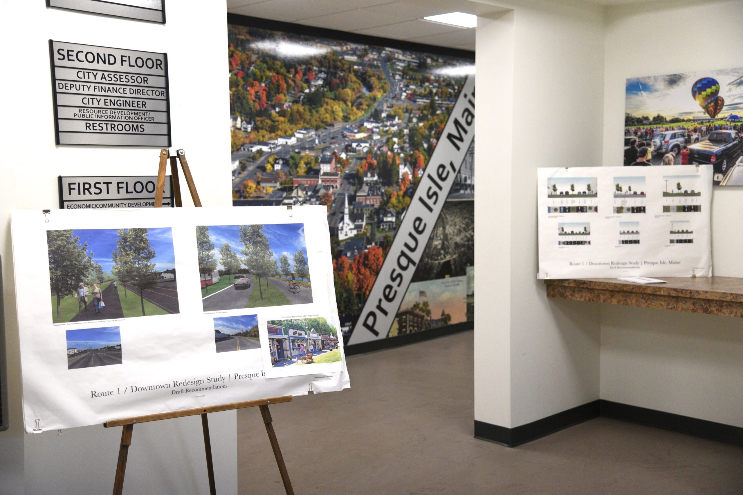
Creating a new sidewalk and reducing some traffic lanes to include a multiuse path are among the options for remaking Presque Isle’s downtown.
Leaders for the Maine Department of Transportation’s Village Partnership Initiative project updated businesses and residents this week. The public had a chance to view some proposed design options on Wednesday.
Through the Village Partnership, Maine DOT wants to revamp town and city centers throughout the state, preserving character while creating safer downtowns that more people can access — whether they drive, walk, bike or use other modes of transportation. Presque Isle signed on in 2022, aiming to boost business and community spirit by getting more people downtown. Wednesday’s meeting was the latest public input session in the multiyear process.
“Everything that we’re looking at is a concept,” said Chris Helstrom of Presque Isle, project manager and senior highway engineer for TYLin International, the San Francisco-based firm the city hired to help plan the redesign. “There’s nothing you’re going to see today that’s set in stone, that can’t be tweaked, altered, adjusted, given local considerations.”
The Village Partnership Initiative launched in 2022 and helps communities with large transformations or smaller improvements, according to the DOT. The DOT works with communities to access grant funding for their projects.
In Aroostook County, Caribou, Van Buren, Madawaska and Fort Kent have also joined Village Partnership efforts. Further south, Dover-Foxcroft, Bangor and Skowhegan are participating.
Team observations and public input identified several problems that plague Main Street, Riverside Drive and adjacent areas, Helstrom said. Among them are traffic that travels too fast, unsafe pedestrian crossings, a lack of sidewalks in some places and severe ruts in the pavement that affect anyone traveling or crossing the street. The area is also unsafe for bicyclists, and the current bike and walking path does not connect throughout the downtown.
Helstrom showed slides depicting suggested changes from the University of Maine at Presque Isle south to Walmart, including Riverside Drive and State Street’s bridge and rotary intersection.
A key option is to create lanes for pedestrians, cyclists and others to separate them from vehicle traffic. That could be accomplished by reducing some of Main Street to three traffic lanes, with a center turning lane, and adding a green space barrier and a multiuse route.
“Connectivity of the bike path from University Street to the downtown and to the recreational facility areas was a key component that was identified,” Helstrom said.
State Street and its bridge could contain the same arrangement so more people could cross safely, extending the multiuse path to the west side of town.
Many people have pointed out that the widely traveled section from Park Street to the “highly dysfunctional” intersection at Walmart has no sidewalk, Helstrom said. The team suggested creating a sidewalk in that area to boost safety for non-vehicle traffic.
People have also been concerned about the rotary intersection that connects Mechanic, State, Parsons and Dyer streets, he said. Options could include leaving it as is, adding a roundabout similar to that by Cary Medical Center in Caribou, or closing off a small part of Dyer Street to eliminate one of the “fingers.”
Engineers conducted traffic-counting studies and assumed a 10 percent growth after the redesign, including fewer trucks after the Presque Isle bypass is finished, according to Errico, who presented a traffic-flow model of the State Street area.
Many vehicles that are traveling north turn left onto State, making it a default left-turn lane. The same thing happens at Academy Street with southbound traffic turning left, he said.
“Left-turn vehicles dominate that lane. So, in essence, you’re not losing one full lane of capacity in this corridor when you’re going from four to three,” he said.
An audience member asked what the project costs were. The overall costs for Presque Isle will be $3.3 million if the city goes ahead with the project, Brown said. That includes $112,000 for the initial study and $307,000 for preliminary engineering which would be the next phase.
The city’s cost is its 20 percent match, according to the partnership plan. MDOT will help Presque Isle seek federal funding for 80 percent of the cost.
Another resident shared personal safety concerns with high-speed traffic and vehicles running stop signs.
“There’s a lot of things that have to be corrected,” he said. “Just restructuring is not going to take care of the issue.”
Educating drivers and enforcing traffic rules will be part of the process, said DOT regional planner Jarod Farn-Guillette. Other safety measures may include shortening the length of crosswalks, flashing lights and the separated multiuse trail, which keeps people away from moving cars.
The study team and residents also discussed the need to maintain farm equipment access, snow removal and having trees that would be less affected by road salt.
The project is still in preliminary stages, speakers emphasized. The council will vote on whether to commit to the project either in September or October, Brown said. The city would likely bond the $3 million.
Whether we do this or not, change will come,” Brown said. “We have a good opportunity here, but it’s up to the community to decide and speak with their council and advise them if they feel that this is the right decision.”
Public comments can be submitted to Helstrom at 207-227-4407 or christopher.helstrom@tylin.com.


